

 2 months ago
78
2 months ago
78
PROTECT YOURSELF with Orgo-Life® QUANTUM TECHNOLOGY
Orgo-Life the new way to the future Advertising by AdpathwayThe new map by the US Geological Service locates the epicenter of the second quake just where most of the damage took place
Since day one, something about the June 24 earthquakes was clear: the most affected area was Venezuela’s central litoral: Vargas, currently La Guaira State. However, many people wondered why this area was so devastated if the epicenters were over 160km away.
Over a month later, the USGS provided the simplest answer: the M7.5 quake’s epicenter was located just west of Catia La Mar, and not in Yaracuy as originally said.
According to the new July 28th update, the first earthquake, magnitude M7.2, was located 21 km ENE of San Felipe (the capital of Yaracuy state) at a depth of 27.6 km, while the second M7.5 was located W of Catia La Mar at a depth of 10.0 km.
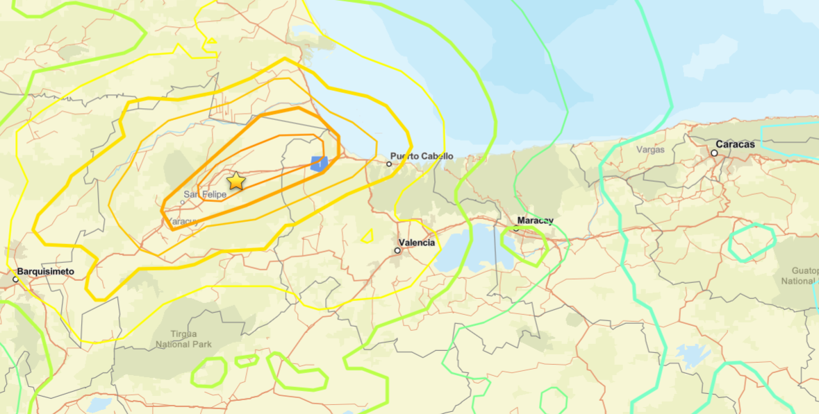 The epicenter of the first earthquake, according to USGS
Why the drastic change of the epicenter?
Earthquakes are not as simple as just a point emanating energy. During an interview a few weeks ago, geologist and geophysicist Michael Schmitz argued that the M7.5 event wasn’t a point, but rather a San Sebastian fault rupture. Based on his preliminary analysis, he estimated that most of the energy was liberated north of La Guaira State. This is congruent with the USGS Cross-section of Slip Distribution analysis:

This theory was also supported by the structural geologist Franck Audemard during an interview with a State-run outlet, when he admitted he was confused about the location of the epicenter in Yaracuy. In his opinion, the difference between the P and S waves, as well as the direction of the earthquake, suggested the epicenter was rather a few kilometers northwest of Caracas. Something that the USGS now confirms.
Both Schmitz and Audemard suggested that the M7.5 earthquake’s epicenter had to be placed where the real energy was released, off the shore of La Guaira. As the fault rupture started in Yaracuy, this wouldn’t fit the usual definition. Nonetheless, they considered the original position misleading.
In both interviews, they still defended that the first earthquake in Yaracuy likely triggered the adjacent San Sebastian fault’s rupture associated with the second earthquake. Hence, we can still talk of a “seismic duplet”. However, they mentioned that further analysis of both earthquakes and their interactions might challenge this theory and merge them as one single event.
This USGS correction, as reliable as it is, still shows one issue: this is a foreign institution with no real equipment on the ground. This greatly affects accuracy. In fact, USGS admitted that “the true location’s uncertainty is likely greater than the calculated 6 km because the initial arrivals are obscured by a foreshock.” Nonetheless, now that local professionals and the USGS agree, a new dramatic correction is unlikely.
It’s also a shameful situation for FUNVISIS, which seems to have copied the USGS information, but we know the Venezuelan seismic agency doesn’t have the operational capabilities to offer a more accurate estimation either.
What does this all mean?
We just got confirmation of what we already knew, but we couldn’t explain. At first glance, Morón, Puerto Cabello, and San Felipe were better candidates as epicenters of the second earthquake given their proximity to the originally estimated origin of the seismic event. However, those cities were clearly spared from the devastation we saw in La Guaira. CCTV Videos also show a stark contrast. While people were thrown off the ground in Caraballeda and Catia La Mar by the earthquake, the videos from Tucacas, Morón and Puerto Cabello show the shaking wasn’t similar at all to what we saw in the central litoral.
This also changes how the effects of the “doblete sísmico” will be studied. The first hypotheses suggested that the effect of both earthquakes combined to create a destructive situation in the capital region. This was quickly picked up by civil engineers, who immediately started hypothesizing about how prolonged severe shaking could have contributed to the damage. However, the new USGS update, combined with local experts’ opinions, suggests that the destructive seismic waves were created by the M7.5 earthquake just a few kilometers away from the disaster zone in La Guaira. This means that the M7.2 one might have played a way smaller role, if any, in the damage to Vargas and Caracas.
This is a complete change of narrative: the collapses in La Guaira and Caracas weren’t caused by two earthquakes 160 km away, but by a very powerful local one, preceded by a distant one. Therefore, shake intensity is likely to become the focus of study for La Guaira and Caracas.
Nonetheless, the effects of two simultaneous earthquakes and their duration might still be relevant for cities equally distant from both epicenters, like Valencia, Puerto Cabello and Tucacas.
What should we learn from this?
Earthquakes are not as simple as we’re taught in school. Otherwise, there wouldn’t be academics and professionals dedicating their lives to understanding them.
It’s important to keep scientific institutions like Funvisis well funded and independent. This epicenter location “inaccuracy” of almost 200 km could have been avoided if the seismic detection network had been operative. Instantly knowing that a M7.5 earthquake happened a few kilometers from La Guaira would have been the first hint of the disaster that was only visible when videos started arriving.















 English (US) ·
  French (CA) ·
  French (FR) ·