

PROTECT YOURSELF with Orgo-Life® QUANTUM TECHNOLOGY
Orgo-Life the new way to the future Advertising by Adpathway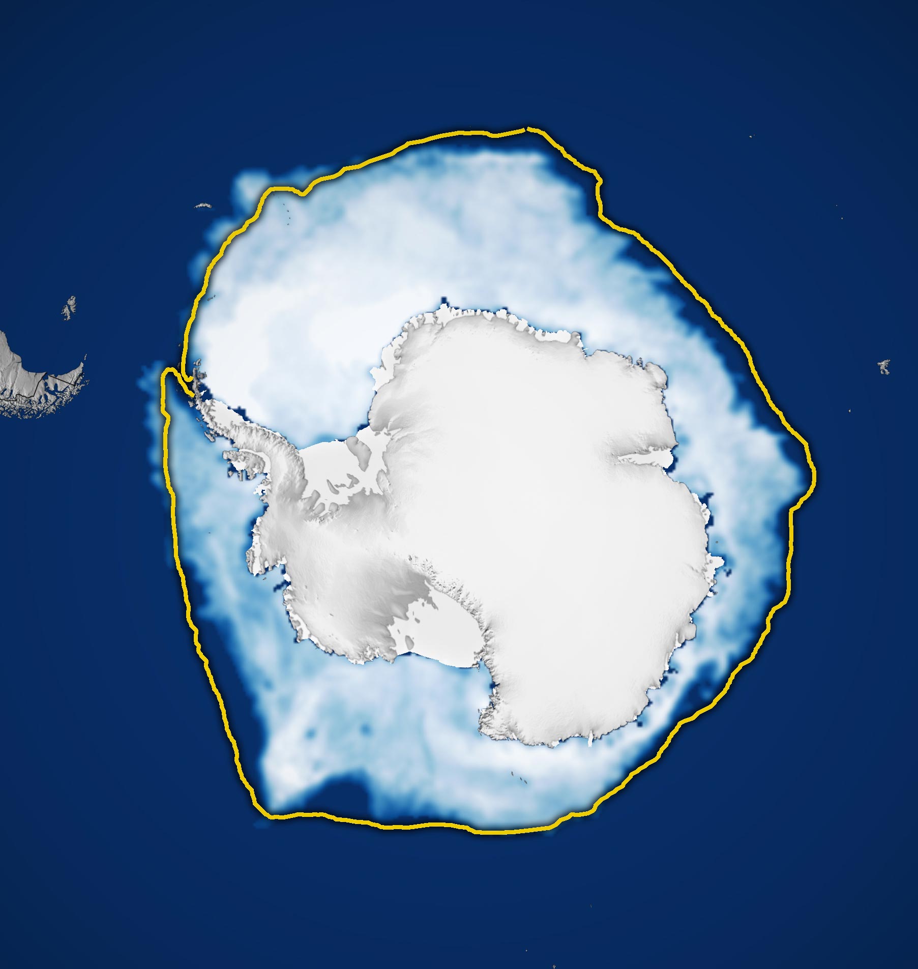 Antarctic sea ice reached its annual maximum extent on September 14, 2026—the third-lowest maximum in the satellite record. Credit: NASA Earth Observatory/Michala Garrison
Antarctica’s sea ice has plunged from record highs to its third-lowest winter peak, revealing a dramatic reversal in the frozen continent’s recent history.
Antarctic sea ice reached one of its lowest winter peaks ever recorded in 2026, continuing a striking shift in ice coverage around the frozen continent. Its annual maximum was the third lowest since satellites began tracking sea ice in the late 1970s.
Antarctica and the Arctic have very different geographies. The Arctic is an ocean surrounded by land, while Antarctica is a massive continent encircled by ocean. This allows Antarctic sea ice to spread across a much larger area during winter. However, as the ice extends into warmer waters farther from the continent, it becomes more vulnerable to melting when summer arrives. Antarctic sea ice typically reaches its greatest extent in September, near the end of the Southern Hemisphere’s winter, before shrinking to its annual minimum in February.
NASA and the National Snow and Ice Data Center (NSIDC) reported that Antarctic sea ice likely reached its annual maximum on September 14 (above). At its peak, the ice covered approximately 17.59 million square kilometers (6.79 million square miles). That made 2026 the year with the third-lowest winter maximum in the satellite record.
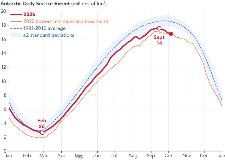
Antarctic Sea Ice Shifts From Record Highs to Historic Lows
For decades, Antarctic sea ice appeared to be moving in the opposite direction of Arctic sea ice. Between 1979 and 2014, the total extent of Antarctic sea ice grew by approximately 1 percent per decade. However, scientists remain uncertain whether this increase reflected a significant underlying trend, since ice coverage around Antarctica can fluctuate substantially from one year to the next.
The growth was particularly notable between 2012 and 2014, when Antarctic winter sea ice set new records for three consecutive years. During the same period, Arctic sea ice was experiencing a steep decline.
That pattern changed dramatically after 2014. Antarctic sea ice stopped expanding in 2015, and substantial declines began appearing in 2016. Although ice coverage has occasionally recovered somewhat, it has generally remained below normal in the years since.
The most extreme conditions occurred in 2023, when Antarctica recorded both its lowest summer minimum and lowest winter maximum in the satellite record. Researchers are continuing to track these changes to determine whether the persistent decline represents a lasting transformation in Antarctic sea ice or could still be explained by statistical fluctuations.
How Satellites Monitor Antarctic Sea Ice Through Clouds
Scientists track the extent of Antarctic sea ice using satellites equipped with passive microwave sensors. These instruments detect microwave energy naturally released by Earth’s surface. Because frozen sea ice emits more microwave energy than open ocean water, researchers can distinguish between the two and calculate how much of the ocean is covered by ice.
One major advantage of this technology is its ability to detect sea ice through clouds. Unlike conventional optical imagery, microwave observations are not blocked by cloud cover, allowing scientists to monitor Antarctica’s frozen waters consistently even when weather conditions are poor.
The continuous satellite record began in late 1978 with measurements from NASA’s Nimbus-7. Observations later came from satellites operated under the Defense Meteorological Satellite Program (DMSP), beginning in 1987, and NASA’s Aqua satellite from 2002 through 2011.
In 2025, researchers began incorporating observations from the Japan Aerospace Exploration Agency’s GCOM-W satellite, helping maintain the long-running record of Antarctic sea ice changes.
NASA Earth Observatory images by Michala Garrison, using data from the National Snow and Ice Data Center.
Never miss a breakthrough: Join the SciTechDaily newsletter.
Follow us on Google and Google News.





















 English (US) ·
 French (CA) ·
 French (FR) ·