

PROTECT YOURSELF with Orgo-Life® QUANTUM TECHNOLOGY
Orgo-Life the new way to the future Advertising by Adpathway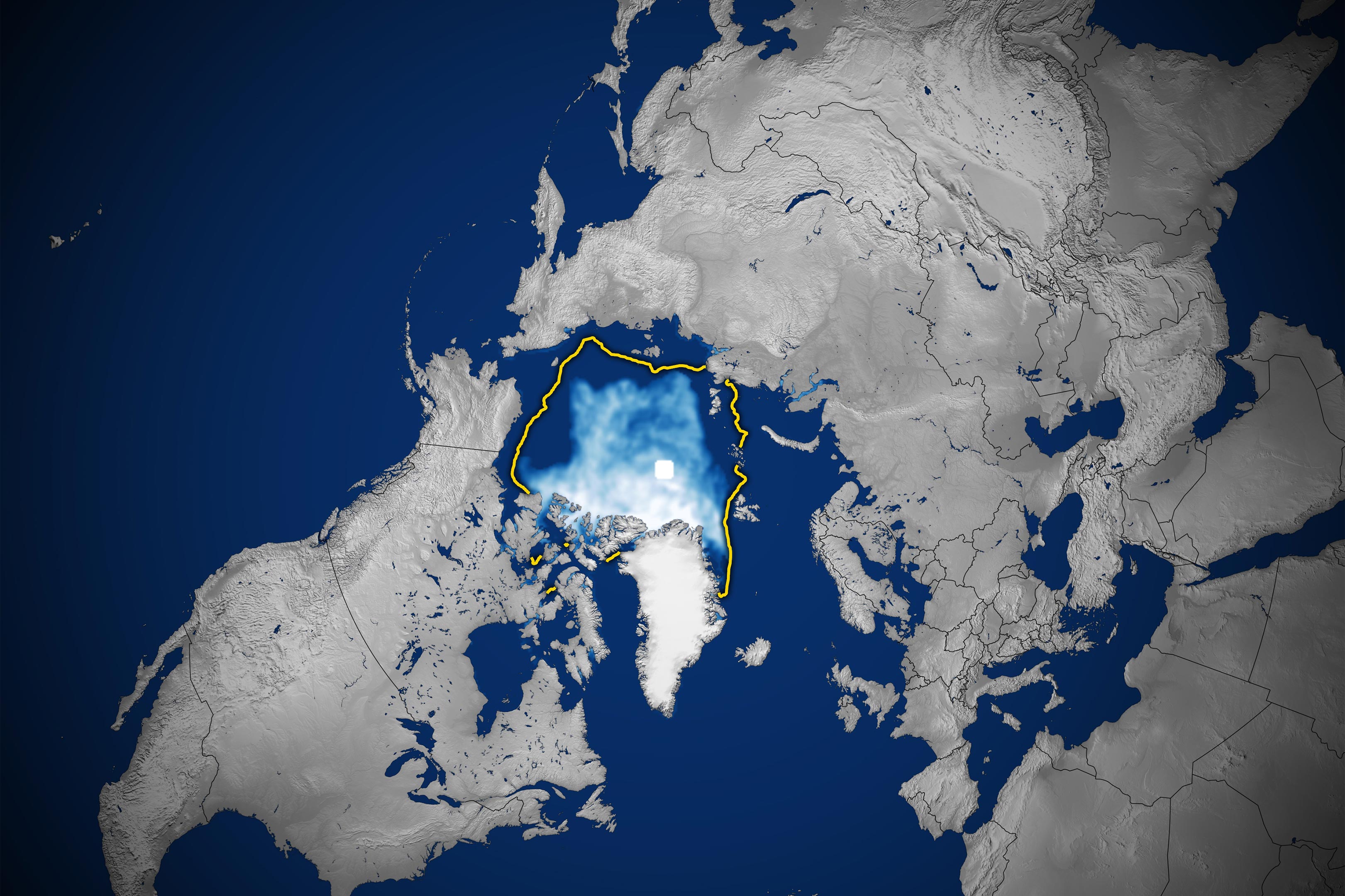 Arctic sea ice reaches its annual minimum extent on September 12, 2026, tying several past years for the 10th-lowest minimum in the satellite record. Credit: NASA Earth Observatory/Michala Garrison
Nearly 50 years of NASA satellite data reveal a troubling decline in Arctic sea ice, raising the possibility of a nearly ice-free summer before 2050.
Satellite observations reveal that Arctic sea ice is covering less of the ocean than it did just a few decades ago, both during the height of winter and at the end of summer. The long-term changes show that the Arctic’s frozen cover is not only shrinking but also becoming younger and thinner.
Each year, a vast layer of frozen seawater expands across the Arctic Ocean as temperatures fall during the polar winter. Ice coverage typically reaches its greatest extent in March before gradually retreating through the warmer months to its lowest point in September. This seasonal cycle has repeated for thousands of years, but satellite measurements show that the amount of ice remaining at both extremes has declined substantially.
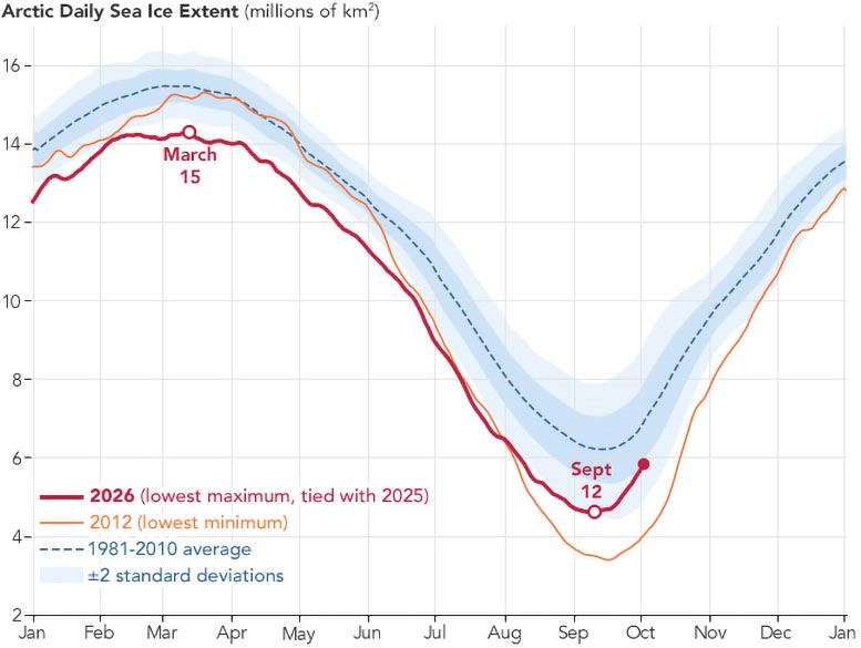
On September 12, 2026, Arctic sea ice reached its annual minimum (above), covering approximately 4.6 million square kilometers (1.78 million square miles). According to NASA and the National Snow and Ice Data Center (NSIDC), that figure ties the minimums recorded in 2008, 2010, and 2025 as the 10th lowest since satellite monitoring began.
Arctic Sea Ice Is Shrinking and Getting Thinner
Satellites have provided an uninterrupted record of Arctic sea ice growth and retreat since late 1978, allowing researchers to track changes across nearly five decades. Although the overall trend has been downward, the decline accelerated during the 2000s, bringing a succession of record and near-record lows.
One particularly striking pattern has emerged. Every summer from 2007 through 2026 falls among the 20 lowest September ice extents ever measured by satellites. The smallest summer ice cover in the entire record occurred in September 2012.
However, the decline in September ice coverage has slowed in recent years, with minimum extents remaining relatively stable over the past decade. Scientists explain that changing weather conditions can strongly influence how much ice disappears during any particular summer.
Increased cloud cover, for example, has reduced the amount of sunlight reaching Arctic ice during the past decade, helping limit additional melting. According to NASA researchers, this has contributed to the recent leveling off in summer ice losses. Even so, September ice coverage remains far below its historical average.
The amount of ice is only part of the story. The Arctic’s remaining sea ice has also become increasingly thin and young.
Scientists have documented a substantial reduction in multiyear ice, which is ice that survives at least one summer melting season. This older ice tends to be thicker and more resilient than ice that forms during a single winter. As it disappears, the Arctic is becoming increasingly dominated by thinner first-year ice, making its frozen cover more vulnerable to melting.
The changes are not limited to summer. Arctic sea ice is also failing to recover to its former extent during the winter months. In March 2026, the annual maximum ice coverage statistically tied the March 2025 maximum for the lowest winter peak in the satellite record.
Could the Arctic Become Nearly Ice-Free?
Natural climate patterns have always affected how much ice covers the Arctic Ocean. One example is the Arctic Oscillation, a pattern of atmospheric pressure changes that influences winds and temperatures across the northern polar region.
These natural fluctuations can help explain why ice coverage varies from year to year. However, they cannot account for the persistent decline observed throughout the satellite record.
Instead, scientists attribute the long-term losses to a combination of natural variability and increasing global temperatures, which have contributed to greater melting across the Arctic.
Looking ahead, climate projections suggest an even more dramatic change may be possible. Scientists estimate that the Arctic Ocean could become essentially free of sea ice during at least one summer before the middle of the 21st century.
How Satellites Track Arctic Sea Ice Through Clouds
Monitoring sea ice across the enormous and often cloud-covered Arctic Ocean requires specialized satellite instruments. Scientists use passive microwave sensors, which detect microwave energy naturally emitted from Earth’s surface.
Frozen seawater and open ocean release different amounts of microwave energy, with sea ice producing a stronger signal. By analyzing these differences, researchers can distinguish ice-covered areas from open water and calculate the total area of ocean covered by sea ice.
A major advantage of this approach is that microwaves can pass through clouds. That allows scientists to monitor Arctic ice consistently, even when clouds obscure the surface from ordinary cameras.
The satellite record began in 1978 with measurements from NASA’s Nimbus-7. Beginning in 1987, satellites from the Defense Meteorological Satellite Program (DMSP) contributed additional observations. NASA’s Aqua satellite also supplied data between 2002 and 2011.
In 2025, researchers began incorporating measurements from the Japan Aerospace Exploration Agency’s GCOM-W satellite, continuing the decades-long monitoring effort.
The white circle visible at the center of each satellite image represents the “pole hole,” an area near the North Pole where satellite instruments have historically been unable to gather measurements. When calculating Arctic sea ice extent, scientists assume that this unobserved region is completely covered by ice.
Together, these satellite observations provide an increasingly detailed picture of how the Arctic’s frozen ocean is changing, revealing a long-term decline that continues despite temporary variations in the pace of summer melting.
NASA Earth Observatory images by Michala Garrison, using data from the National Snow and Ice Data Center.
Never miss a breakthrough: Join the SciTechDaily newsletter.
Follow us on Google and Google News.



















 English (US) ·
  French (CA) ·
  French (FR) ·