
PROTECT YOURSELF with Orgo-Life® QUANTUM TECHNOLOGY
Orgo-Life the new way to the future Advertising by AdpathwayWith a berry farm, gin distillery, craft brewery, local produce store, and the smallest pub in Victoria to visit along the way, the I Left My Wallet in Eldorado bikepacking loop through quiet forests on gold-rush-era backroads is more about rhythm and place than effort and difficulty. The creekside campsite is a treat in any season, and on warmer days, a swim in Lake Sambell at ride’s end is the icing on the cake…
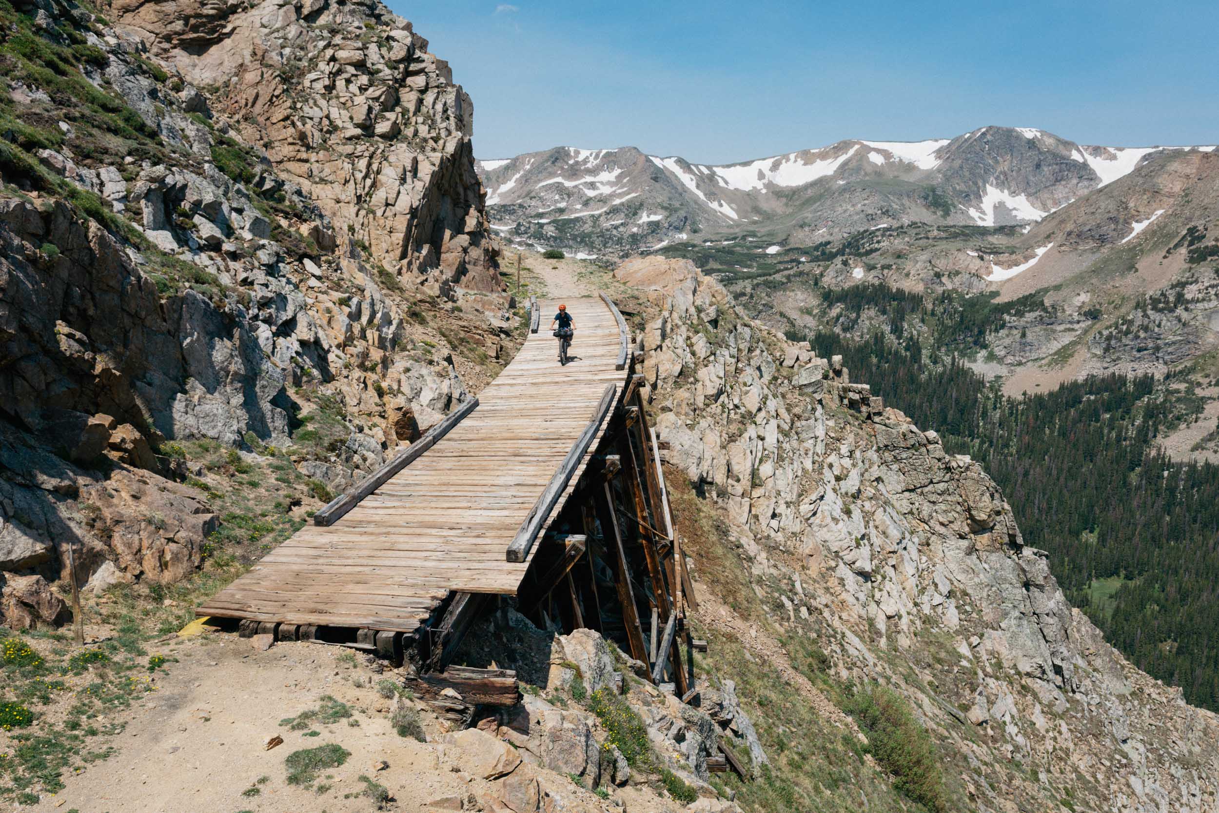
This overnighter threads together some of northeast Victoria’s best riding country, linking Beechworth, Eldorado, and Stanley by way of gold-rush backroads, quiet forest tracks, and long, easy-going ridgelines. It’s the sort of landscape that reveals itself gradually rather than all at once: open farmland giving way to dry eucalypt forest and smooth gravel interrupted by the occasional reminder that this is still real country. The riding is varied without being chaotic, encouraging a steady pace and plenty of looking around rather than a head-down effort.
There’s a strong sense of history running through the route. Old mining towns, water races, and information boards hint at the thousands of people who once moved through this country on foot and on horseback, seeking their fortune long before bikes were part of the picture. A detour to the Yeddonba Aboriginal Cultural Site adds further depth, offering a quiet reminder that these lands have been walked for far longer still. It’s a ride that feels grounded in time as much as place.
The overnight camp beside Reedy Creek is a highlight—shaded, calm, and generous—and sets the tone for the trip. Taking two days to ride what many locals knock over in one opens the door to a different experience altogether: time for a swim, a slower dinner, and perhaps even the temptation of a pub meal in Eldorado—at the smallest pub in Victoria, no less. The ride’s pace is unhurried if you leave early enough, and the reward is arriving at camp with daylight and energy to spare.
Food, coffee, and local colour play their part too. Beechworth Berries appears early enough to test your resolve, Stanley’s pub and store provide a perfectly timed pause on day two, and having Beechworth at either end invites a longer stay, before or after the ride. This isn’t a route about ticking off kilometres or chasing gradients; it’s about moving smoothly through a lived-in landscape and enjoying the quiet satisfaction that comes from slowing things down.
Route Difficulty
As an overnight ride, I Left My Wallet is approachable without being trivial, and rewarding without being a sufferfest. The climbs are steady rather than steep, the surfaces are predictable (with a little extra spice on the singletrack sections), and the daily distances allow time to settle into a rhythm, making it well-suited to riders testing gear or even tackling their first bikepacking overnighter. For those riders, it rewards sensible pacing, basic preparation, and an understanding of self-supported riding. More experienced riders will appreciate it as an enjoyable, low-stress weekend away where the challenge comes from moving smoothly through the landscape rather than pushing personal limits.
Route Development: The route puts a few twists on a slightly shorter favourite local loop and was mapped this way specifically for the Fill in the Map project. Every road and track has been ridden many times by the author and other Beechworth riders—though usually in a day, which rather misses the point. Taking it slower, with an overnight stop, is a much better idea. It also opens up chicken parmy as a pub dinner option in Eldorado, which is reason enough.
![]() This route is part of the Local Overnighter Project, which was created to expand our growing list of worldwide bikepacking routes—the first and largest of its kind—and create an independent map and catalog of great bikepacking overnighters, curated by you, from your own backyard. Our goal is to have accessible routes from every town and city in the world. Learn More
This route is part of the Local Overnighter Project, which was created to expand our growing list of worldwide bikepacking routes—the first and largest of its kind—and create an independent map and catalog of great bikepacking overnighters, curated by you, from your own backyard. Our goal is to have accessible routes from every town and city in the world. Learn More![]()
Submit Route Alert
As the leading creator and publisher of bikepacking routes, BIKEPACKING.com endeavors to maintain, improve, and advocate for our growing network of bikepacking routes all over the world. As such, our editorial team, route creators, and Route Stewards serve as mediators for route improvements and opportunities for connectivity, conservation, and community growth around these routes. To facilitate these efforts, we rely on our Bikepacking Collective and the greater bikepacking community to call attention to critical issues and opportunities that are discovered while riding these routes. If you have a vital issue or opportunity regarding this route that pertains to one of the subjects below, please let us know:
- Eldorado Pub: Can you stay loyal to your camping stove’s rehydrated delights, or will the chicken parmy and cold beer at the Eldorado pub prove too tempting? This choice, more than anything else, sits at the heart of the route.
- Mt. Pilot Lookout: If you can drag yourself away from the champagne gravel backroads, the Mt. Pilot lookout is just 500m off-route and delivers 360-degree views that are well worth the detour.
- Stanley’s Magic Forest is an ideal spot for a quiet #coffeeoutside towards the end of the ride. Towering redwoods and dappled light create a cool, shady pocket you’ll find hard to leave.
- Beechworth Berries comes up just 13 km in, which is early by any sensible measure, but that’s no reason to ride past homemade ice cream and the chance to hand-pick fresh berries for ride snacks.
- Camping beside Reedy Creek: With the price of gold where it is, camping beside Reedy Creek could almost feel like a financial strategy. In the gold-rush years, thousands of prospectors would have camped right where you’re sleeping, and even today the creek is still known to carry traces of gold. BYO goldpan.
- The Yeddonba Aboriginal Cultural Site is well worth the short detour, offering a quiet reminder that these lands have been walked for thousands of years, long before any of us thought to ride through them.
- Excellent gravel day loops on either side of the overnight in Beechworth and Stanley. The usual routine is to start at the old Gaol and finish at the brewery — the locals seem to have this figured out.
When to go:
- The route works in all seasons, although spring and autumn offer the most comfortable temperatures — unless you’re particularly fond of riding in the heat or the cold.
Logistics:
- If you’re driving, park in Beechworth near the old Gaol or a block back from the main street. Coming by public transport? Take the train to Wangaratta and follow the Murray to Mountains Rail Trail from Wangaratta to Beechworth (40 km — allow an extra half day).
- The nearest camping gear shops are in Wangaratta and Albury. For bike-related help, go and see Trav at Beechworth Cyclery.
- The route can be ridden in either direction, with the overnight camp almost exactly halfway. I recommend riding it anti-clockwise — mostly because the Stanley Store does an excellent coffee and cake, which is exactly what you want late on day two.
What Bike:
- A gravel bike with 40mm tyres or wider will handle the route comfortably, including the short singletrack sections.
Dangers & Annoyances:
- Mobile phone coverage drops out in places, so carry a Garmin inReach or similar device and let someone know your plans before you go, just in case.
- This is Australian sidecountry through forest and farmland, so expect wildlife including kangaroos, koalas, goannas, plenty of insects, spiders, and snakes — and the occasional farm dog. Ride with awareness and prepare accordingly.
Beechworth has two caravan parks and plenty of short-stay accommodation if you’re staying before or after the ride. The overnight camp is near Eldorado on Reedy Creek, or you can opt for a grassy site and a hot shower at the Eldorado Caravan Park if you feel like a bit of comfort.
Reliable water is available at Wooragee (14 km), the berry farm (16 km), Eldorado (48 km) and Stanley (82 km). You’ll cross creeks between these points, but these aren’t sparkling mountain streams. It’s best to carry enough to see you through — especially in summer. Food options include the berry farm for an ice cream stop, Eldorado for the pub or general store, and Stanley for the pub, produce store and café.
Technical Difficulty: The majority of the route is on smooth gravel backroads. Loose gravel can sometimes cause problems on the descents for less experienced riders, the end of Long Range Track is a little spicy, and there’s a short section of MTB singletrack on day 2, but overall this is not a technical route.
Physical Demand: Less than 50km each day is manageable for most. The climbs are always followed by descents that feel well earned.
Resupply and Logistics: Starting and ending in the town of Beechworth makes logistics simple. Leave your car in town and stock up pre-ride, then reward yourself post-ride at the local craft brewery. En route there are only two food options and you’ll find long-ish sections with no water. The overnight stop in Eldorado gives you the option of an evening pub meal and a coffee from the general store in the morning. The Stanley Store on day 2 is a welcome sight.
Climbing Difficulty: The steady climbs reward patience rather than power. The long climb up Six Mile Road on day 2 could catch you out if you go too hard too early.
location Beechworth to Eldorado
Day 1 (43km, 516m)
The first day begins with an easy downhill roll along the rail trail to Wooragee and the berry farm, before turning north onto the smooth gravel roads of the Chiltern–Mt Pilot National Park. Smooth, that is, until you reach the end of Long Range Track — take care negotiating the steeper, chunkier sections here. Once onto Woolshed Road, keep an eye out for historic sites and information boards that tell some of the area’s story. Set up camp near Reedy Creek for the night, or roll into Eldorado for the chicken parmy you promised yourself you’d resist.
locationEldorado to Beechworth
Day 2 (51km, 983m)
Day two starts with a punchy climb up Mason’s Road, leaving the National Park once you pass through the first of three farm gates. Leave gates as you find them and watch for cattle. The grind up Six Mile Road is quickly forgotten after the descent through the forest and a stop at the Stanley Pub or Store for coffee and cake. From here it’s mostly downhill back to Beechworth, though the short detour to the Magic Forest is well worth squeezing in if time allows.
Expect a mix of loose gravel, sealed road, farm tracks, singletrack and, depending on the season, mud or sand — a constantly changing backdrop that explains why the locals ride here so often.
Terms of Use: As with each bikepacking route guide published on BIKEPACKING.com, should you choose to cycle this route, do so at your own risk. Prior to setting out check current local weather, conditions, and land/road closures. While riding, obey all public and private land use restrictions and rules, carry proper safety and navigational equipment, and of course, follow the #leavenotrace guidelines. The information found herein is simply a planning resource to be used as a point of inspiration in conjunction with your own due-diligence. In spite of the fact that this route, associated GPS track (GPX and maps), and all route guidelines were prepared under diligent research by the specified contributor and/or contributors, the accuracy of such and judgement of the author is not guaranteed. BIKEPACKING.com LLC, its partners, associates, and contributors are in no way liable for personal injury, damage to personal property, or any other such situation that might happen to individual riders cycling or following this route.
Further Riding and Reading
Here are some connected/nearby routes and related reports...
Please keep the conversation civil, constructive, and inclusive, or your comment will be removed.


 English (US) ·
  French (CA) ·
  French (FR) ·