

.png) 1 month ago
8
1 month ago
8
PROTECT YOURSELF with Orgo-Life® QUANTUM TECHNOLOGY
Orgo-Life the new way to the future Advertising by Adpathway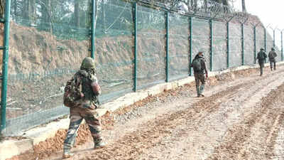
Several of the named sites on the map carry the weight of India-China conflict.
GUWAHATI/NEW DELHI: The updated Survey of India map has assigned standard place and feature names to 27 Arunachal Pradesh sites, including four mountain passes and a high-altitude lake, as part of the Union government’s strategy to remove any ambiguity on demarcation of territory and counter China’s repeated attempts to rename places on this side of the McMahon Line.The MHA said on Friday that the names were finalised in consultation with the Arunachal Pradesh government. “Identifying them formally on the Survey of India map is aimed at facilitating their accurate recognition and better awareness among the public.”Of the 27 sites identified on the map, one is a monument. Three of the rest — Longju, Maja & Bisa — are strategically important border villages in Upper Subansiri district.
There are also three passes along the McMahon Line, Dzo La, Riza La and Pukur La, in the same district. Thag La pass, a 1962 battleground, lies on the border in Tawang district.“These places are already marked on Indian military maps, even those of 1962 vintage. Identifying them on Survey of India maps is a bold counter to China,” a source said.Several of the named sites carry the weight of India-China conflict. Longju was one of the earliest flashpoints in the boundary dispute and was occupied by Chinese troops in 1959.
Thag La overlooks Namka Chu valley, where the 1962 conflict began after Chinese forces crossed the McMahon Line.Jaswant Garh, in Tawang, commemorates Rifleman Jaswant Singh Rawat, one of the most celebrated heroes of 1962 war. The Sher-e-Thapa Memorial in Upper Subansiri honours Hav Shere Thapa, whose resistance at Rio Bridge significantly delayed the Chinese advance in 1962. The lone lake named is Sambho Sarovar, a high-altitude glacial lake.
The remaining land areas include Bara Kundun, Chhota Kundun and Dhan Bari in Anjaw district; Pritnagar, Buddhamandir, Jairampur, Teritnagar and Ramnagar in Changlang; Sagar, Padma, Jyotinagar and Baisakhi in West Kameng; Chhota Ropuk and Bara Ropuk in Upper Subansiri; and Shivaji Nagar, Sunpura and Kamlang Nagar in Lohit.In April, China announced Chinese names for 23 locations in Arunachal Pradesh, which Beijing refers to as “South Tibet”. The external affairs ministry then said assigning “fictitious names” wouldn’t alter the reality that Arunachal Pradesh “was, is, and will always remain an integral and inalienable part of India”. China has carried out similar renaming exercises periodically.McMahon Line demarcates the boundary between India and China in the eastern sector, separating Arunachal from Tibet.










 English (US) ·
  French (CA) ·
  French (FR) ·